Close
Results 1 to 10 of 10

Thread: GPS

Hybrid View

Previous Post Previous Post   Next Post Next Post
  1. #1
    Machine Gunner birddog's Avatar
    Join Date
    Nov 2010
    Location
    Evergreen, CO
    Posts
    1,100

    Default

    Quote Originally Posted by Inconel710 View Post
    You won't find a stand alone GPS for both driving and hiking. I'd also avoid the touch screen Garmins like the Oregon - even if the screen does keep working in the cold, you'll need a special glove or constantly take your glove off to use it. For a hunting GPS, the new Etrex20 is probably the cheapest one you'll find that will take the Hunting GPS Map SD card. I had an old Etrex and that thing just worked. That would be my choice if I were spending the money.

    On the spendy side, I've heard nothing but good things about the Garmin GPSMAP 62 series. They're also compatible with Hunting GPS Maps.

    All of that to say, I'll be using my beat up and old iPhone 3G and Gaia GPS app for my hunting this year. Backed up, of course, by a paper topo map and Suunto MC-2 compass.
    Just what I was looking for.

    I don't need a driving/ hiking unit, just hiking and hunting. I was thinking stand alone simply for the purpose of using the hunting gps maps that show plat and owner information. looks like their maps are onto available for garmin stuff.

    I wasn't aware that the iPhone could be used without a signal. I am going to look into that option. I already have the phone and for fairly cheap I could buy a solar charger or battery based charger that I can use to keep it charged.

    Anyone know if any of the apps will show landowner information and more importantly hunting gum units?

    Also, are the iPhone apps displaying 24k maps?

  2. #2
    Zombie Slayer Zundfolge's Avatar
    Join Date
    Jul 2007
    Location
    Wichita, KS (formerly COS)
    Posts
    8,317

    Default

    Quote Originally Posted by birddog View Post
    I don't need a driving/ hiking unit, just hiking and hunting.
    Get something super simple that is inexpensive and gives your your coordinates. Something like the Bushnell HuntTrack or BackTrack (make sure its one of the models that displays the cords, so not the cheapest one) or if you prefer Garmin, an eTrex.

    Then get some USGS quad maps of the area you want (and/or BLM maps, and/or Rocky Mountain Huntin' Maps) and a good compass in case you lose signal.


    Hell, one of the guys that used to work where I work (MacVan Maps) used to GeoCache with paper maps and a compass ... said they were more accurate.

    Of course if you insist on digital, we sell the Big Game CD Maps for Colorado. They have a free app for iPhone to read the maps.
    Modern liberalism is based on the idea that reality is obligated to conform to one's beliefs because; "I have the right to believe whatever I want".

    "Everything the State says is a lie, and everything it has it has stolen.
    -Friedrich Nietzsche

    "Every time something really bad happens, people cry out for safety, and the government answers by taking rights away from good people."
    -Penn Jillette

    A World Without Guns <- Great Read!

  3. #3
    Zombie Slayer
    Join Date
    Sep 2009
    Location
    Pueblo
    Posts
    6,930

    Default Hiking GPS

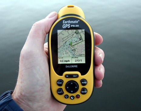
    I use a Delorme PN 20 handheld GPS. I like it because it has interoperability with Delorme Topo USA software on my desktop and my laptop too. I use a USB GPS receiver for my laptop, Delorme Earthmate LT20. All this stuff was quite expensive when I bought it. Now it is fairly cheap on Ebay. Laptop GPS puts the other GPS to shame, keyboard, screen size etc.

    Delorme.com


Posting Permissions

  • You may not post new threads
  • You may not post replies
  • You may not post attachments
  • You may not edit your posts
  •